 The Florida Keys island chain. |
Monroe County officials are concerned about water quality degradation in the canals. According to George Garrett, director of the Monroe County Marine Resources Department, there are currently about two dozen county canals with no access to open water—they remain plugged due to changes in environmental regulations imposed in the 1970s.
Residents have also long reported a problem with flotsam entering open canals with the accumulating seaweed decaying and fouling the waterway.
Challenge
 Seaweed and flotsam buildup in a Florida Keys canal. |
To date, there has been no systematic monitoring of canal water quality in the Florida Keys. To evaluate what type of remedial actions may be necessary for the canals, ESRI Business Partner MACTEC Engineering and Consulting, Inc., was awarded a contract to undertake a survey of canal conditions throughout the Keys.
The goal of this project was to bring as much information as possible into a single GIS on the physical characteristics, potential pollution sources, and existing water quality of each of the canals.
MACTEC utilized ArcView to not only compile, process, and relate the existing data but also to generate extensive attribute data for the residential canals. With the canal inventory complete, ArcView software's spatial querying capabilities proved to be key throughout the assessment and analyses process.
Canal Inventory and Data Development
MACTEC spatially located the residential canals through a process that began with digitizing all water bodies from the 1998 aerial photographs of the Florida Keys, obtained from Florida Department of Transportation District 6 and available as part of the Florida Geographic Data Library 1:24,000 black and white aerial photography.
The aerial images were selected because of their relatively high resolution and extensive coverage of the study area. After digitizing the water bodies, MACTEC performed quality control through select field verifications, interviews with local home owner associations, and distribution of the water body layer to local agencies for comments. During this task, the layer was refined to include only the residential canals located within the Florida Keys, which were the focus of the study.
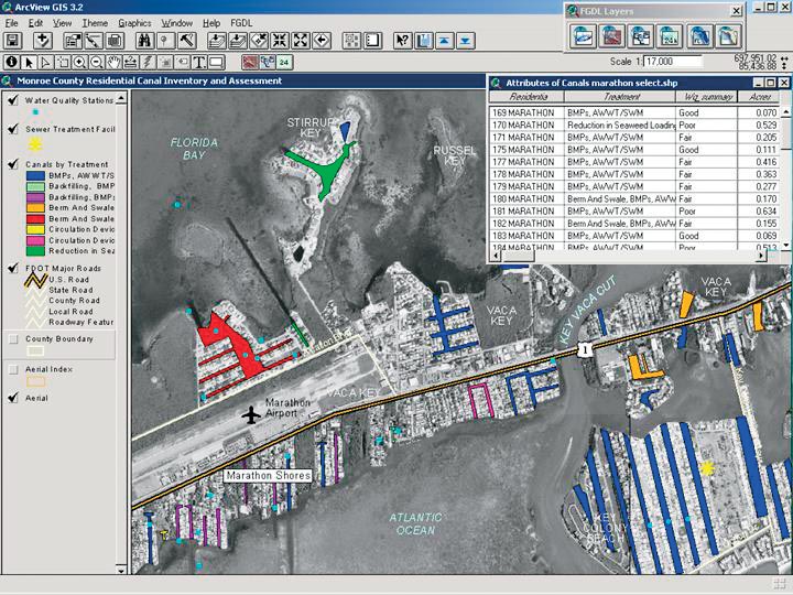 Residential canals color-coded by recommended canal treatments. |
These attributes included canal area, width, length, number of mouths, degree of convolution, and latitude and longitude of the centroids of the canals. The number of convolutions was determined by measuring the number of 90-degree turns, or fractions of 90-degree turns, in the canal.
The existing data that had been gathered, inventoried, and evaluated during an extensive data compilation effort was processed and input to the project GIS and related to the residential canals. Information varied from topography and land use information to water quality data dating back 40 years.
The water quality data was particularly challenging to incorporate, as historically it had been developed on a project by project basis that included only small sections of the Keys. Many of the source data sets lacked a complete metadata record of the methodologies and instrumentation used.
Although the historical water quality data was of value to see general trends in parameter variability, it was impossible to compare many data sets that were collected using different (or undocumented) methods. The data quality control review included a review of methodologies and documentation. Only data with comparable methods and documented protocols could be confidently compared between different monitoring stations over time. A separate GIS layer was provided as a point file of existing water quality monitoring station locations and linked to the sampling data.
Canal Assessment and Analyses
With the residential canal inventory complete and the GIS data set developed, ArcView software's spatial querying and analyses capabilities were used throughout the canal assessment process.
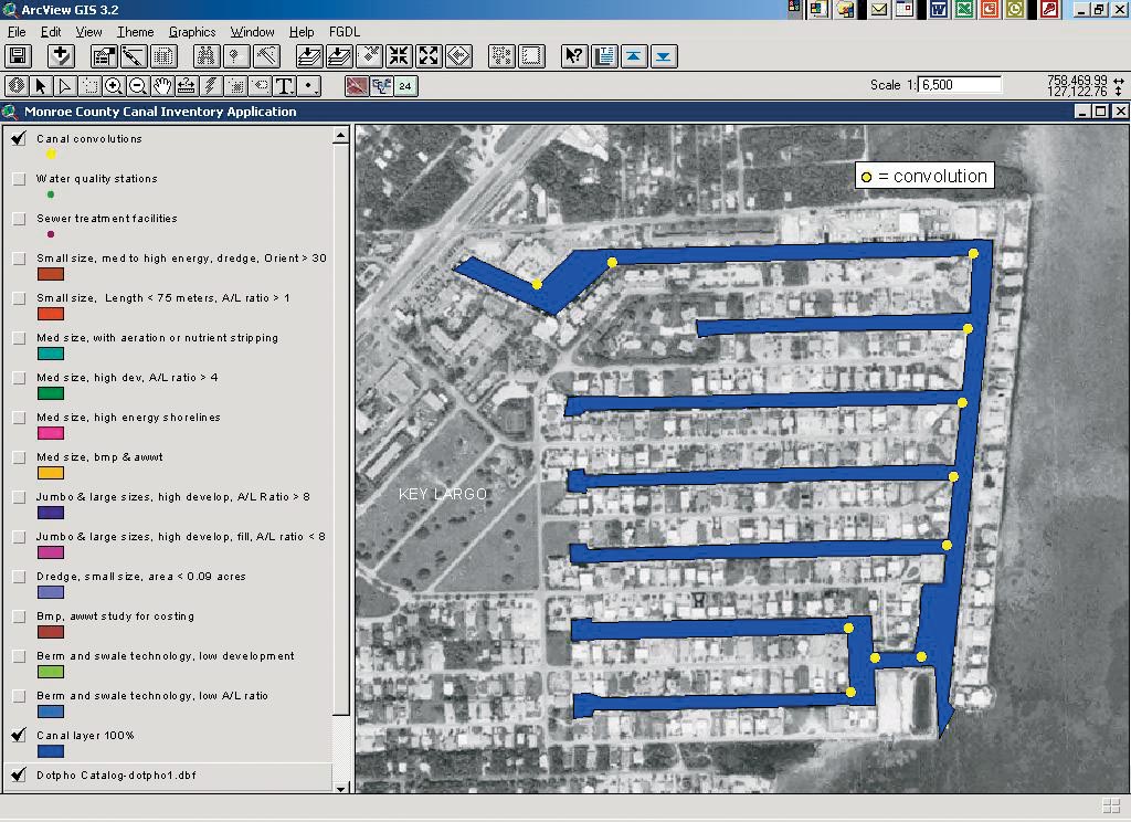 The 11 convolutions in the Port Largo Canal system. |
A classification model for the canals was created with canals queried and grouped by common physical characteristics. MACTEC developed a method to determine estimated water quality for each canal based on its classification, and the soundness of the developed methodology was verified by comparing the estimated water quality with the actual water quality where data was available. The values agreed, and water quality could then be estimated for all canal systems without a large-scale field effort.
GIS was also used to develop a strategy for selecting the canal specific treatment approaches and technologies that would improve water quality. ArcView was again used to query the physical attributes, which were the major factor in determining the most applicable and cost-effective options. The process also presented a methodology for prioritizing canals based on available funding or immediate interest of local residents to "do something" to improve canal water quality.
As a final step, ArcView was used to identify data gaps and recommend the type of canals Monroe County should sample if it decides to conduct a field sampling effort.
The Bottom Line
Management of residential canal water quality will become increasingly important to Monroe County as build-out of the Florida Keys continues. A comprehensive and systematic approach to canal mitigation will be necessary to prevent long-term impact on adjacent marine resources.
 A water quality parameter data report is linked to each canal. |
ArcView has helped Monroe County establish a methodology for grouping canals by design features most likely to impact water quality, thus providing a method for assessment of treatment technologies for individual canal systems. (Source: ArcNews, ESRI)
By Wendy Leonard, Project Manager, and Karen Zahalka, GIS Manager, MACTEC Engineering and Consulting, Inc.
For more information, contact George Garrett, director of the Marine Resources Department, Monroe County (tel.: 305-289-2507, e-mail: garrett-george@monroecounty-fl.com); Wendy Leonard, project manager, MACTEC, Inc. (tel.: 305-826-5588, e-mail: wcleonard@MACTEC.com); or Karen Zahalka, GIS manager, MACTEC, Inc. (tel.: 770-421-3447, e-mail: kazahalka@MACTEC.com).