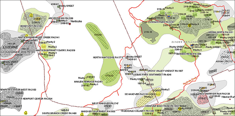
 Map depicting specific abandoned mine problem features and active mining permits. Green tinted areas are reclaimed, while red and yellow tinted areas represent unreclaimed high-priority features. |
As recently as 30 years ago, coal mining companies weren't required to clean up and restore the land they excavated. Streams ran orange, green, and white with heavy metals leached from nearby mines. Strip pits with sheer cliffs were a hazard, causing many people to fall to their deaths. Pennsylvania was left with more than 200,000 acres of mine-scarred land and 5,000 miles of polluted streams. As the impact of surface mining became evident in the mid-1970s, Congress passed the Surface Mine Control and Reclamation Act (SMCRA) in 1977. SMCRA attached a per-ton fee to all extracted
coal to create an interest-accruing federal reclamation fund. The fund is maintained by the United States Department of the Interior Office of Surface Mining (OSM) and is dispersed to states and Native American tribes that still face problems caused by coal mines abandoned before 1977.
Because Pennsylvania leads most states in the amount of reclamation that needs to be done, in 2006, Congress authorized an increase in Pennsylvania's reclamation allotment to $1.4 billion over the next 15 years. With so many abandoned mines still awaiting reclamation in Pennsylvania, EPCAMR sought a way to more efficiently pinpoint the areas in need of remediation. Although the new allotment will significantly increase the work that can be done, $1.4 billion still needs to go a long way.
With a grant from the Foundation for Pennsylvania Watersheds and an agreement with the OSM's Technical Innovation Professional Services (TIPS) Program, EPCAMR used ArcGIS Desktop software's ArcMap and the Publisher extension to create a tool to keep track of abandoned mines. Called the Reclaimed Abandoned Mine Land Information System (RAMLIS), the application creates highly detailed maps at different scales with layers of information that help identify the areas most in need of remediation. RAMLIS also combines state, federal, and local data in maps that reveal all the components of mines, such as mine discharge points, backfilled strip pits, and reclaimed mine shafts. To work safely and effectively, reclamation crews must know the location of these features. Knowing the location of flooded voids, for example, can potentially save enormous expense—and even lives.
The dynamic, interactive maps assist reclamation efforts because they allow the public and local municipalities to understand what features are contained within a mine site and which features can be fixed using SMCRA funding. Map layers show a multitude of problems caused by leaving mines unattended. For example, the quality of water running off these sites is identified in a stream layer from the Pennsylvania Department of Environmental Protection (DEP) called the Integrated List of Waters. This layer shows streams that do not meet their intended use because pollution from the seepage of mining by-products drains into the stream. By turning on this layer, users can see certain sections of a stream that are impacted by mine drainage of heavy metals, such as iron or aluminum, into the stream. Toxic discharge from this runoff also decreases the pH to uninhabitable levels for fish and other aquatic organisms.
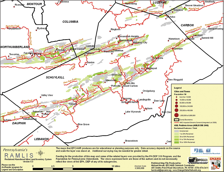 Map showing streams impacted by pollutant runoff from abandoned mine in Schuykill County, Pennsylvania. |
Recently, EPCAMR took the application on the road to demonstrate its benefits to municipal officials throughout northeastern Pennsylvania. The goal of the workshops was to show how ArcGIS not only maximizes the value of reclamation budgets but also increases public awareness of mine hazards. In a flagging economy, and following a string of harrowing coal mine accidents in the past few years, EPCAMR's message couldn't have been more timely.
To show municipal planners and public officials what GIS was capable of, EPCAMR offered to produce up to three free maps for municipalities containing abandoned mines. One map was required to depict mined-out land, while the content of the other two was left up to elected officials based on available data. In a survey conducted after the tour, many of these municipalities responded that the new maps were helpful, since the old maps used for planning and maintenance were an average of 15 years old. Several municipalities were also interested in obtaining their own GIS software and technicians.
"If we can convince public officials who are in charge of making sound land-use planning decisions for their communities, it might turn the light bulb on for them," says Robert Hughes, regional coordinator for EPCAMR. "We're trying to say, 'Let us show you how GIS can be used to effectively allocate a limited amount of funding and resources over time.'" ArcGIS helps municipalities, as well as state and federal officials, by providing concrete evidence of potential health and safety hazards, such as subsidence-prone areas. "Pollution from residual coal mine chemicals, illegal dumping, and land cave-ins is a real concern to some of these communities," says Hughes. "GIS gives us the best solution to identify and respond to these problems on a local level."
To date, approximately 22,500 acres of mine lands in Pennsylvania have been cleaned up, and more than 280 mine drainage treatment systems are in place to treat polluted water. EPCAMR hopes the workshops in Pennsylvania continue to spread the GIS message to other organizations. (Source: ArcNews, ESRI)