Recently developed GIS-based aquifer vulnerability models provide valuable groundwater protection tools with wide-ranging applications throughout Florida. Intended to enhance protection efforts for Florida's fragile drinking water resources, the models provide new options for community planners, public works staff, environmental professionals, storm water and wastewater engineers, and local governments.
These models are extensively used in many areas, including land-use planning, identification of recharge areas, wastewater planning, wellhead protection, identification of environmentally sensitive areas, storm water management, and spring protection.
The Floridan aquifer system is the most important source of water in Florida, supplying the state with literally billions of gallons of water per day. In addition, the Floridan aquifer system is the source of several hundred freshwater springs, which are valuable resources from a tourism perspective, bringing thousands of visitors to the state per year.
Groundwater protection efforts in Florida are supported by five water management districts, the Florida Department of Community Affairs (FDCA), Florida Department of Environmental Protection (FDEP), Florida Department of Health, and numerous local environmental agencies.
Having a reliable tool that prioritizes areas of higher aquifer vulnerability for both water resource and growth management is a critical requirement for these organizations. Aquifer vulnerability modeling meets this requirement, allowing a proactive approach to the protection of aquifer systems, saving significant time and increasing the value of protection efforts.
Various stakeholders throughout Florida agreed that a new, modern tool was necessary to meet the need to protect groundwater resources. The consensus of many stakeholders was that any tool must take advantage of recent advancements in GIS, be easy to implement, and rely heavily on the state's wealth of geographic and water-resource information that has been carefully collected over the years.
The project that emerged, the Florida Aquifer Vulnerability Assessment (FAVA), was undertaken by the Florida Geological Survey of FDEP. Stakeholders from all of Florida's five water management districts; FDCA; FDEP; Hazlett Kincaid, Inc.; SDII Global Corporation; and the United States Geological Survey (USGS) acted as advisers to the project.
The stakeholder group also peer-reviewed the final model to help strengthen its defensibility, and many of these stakeholders now regularly use FAVA results to complete agency tasks.
The primary goal of the FAVA project was to provide a scientifically defensible water resource management and protection tool that facilitated land-use planning to help minimize impacts on groundwater quality. The project's designers sought to generate meaningful and useful tools to help ensure balanced protection and future use of groundwater resources by characterizing the natural vulnerability of aquifer systems.
ArcGIS Desktop was selected as the development platform for the FAVA project because of the state's existing investment in the software suite. After careful assessment of available modeling techniques that would best suit an aquifer vulnerability analysis, the Arc Spatial Data Modeler, or Arc-SDM, was also selected.
Arc-SDM was programmed by Don Sawatzky under the direction of Dr. Gary Raines of USGS and Dr. Graeme Bonham-Carter of the Geological Survey of Canada. Arc-SDM requires ArcGIS Spatial Analyst and is currently available on ESRI's ArcScripts Web page: arcscripts.esri.com/details.asp?dbid=15341. Analytic techniques of Arc-SDM are being evaluated for inclusion in future versions of ArcGIS Spatial Analyst.
Arc-SDM consists of geoprocessing tools used to generate predictive maps describing probabilities of occurrences of specific events in a study area. The preferred Arc-SDM modeling component selected for the FAVA project was Weights of Evidence; this method is data driven and involves the combination of diverse spatial data to describe and analyze interactions and generate predictive models.
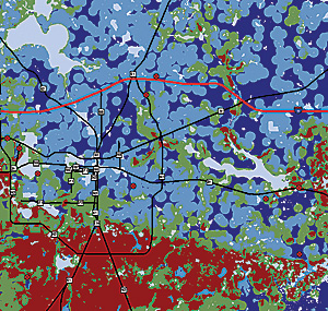
 Training points are necessary for the Weights of Evidence analysis in Arc-SDM (shown here in red) and are used as indicators of aquifer vulnerability. |
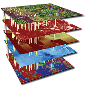
This input data included digital elevation, aquifer recharge, subsurface material properties, sinkholes/karst features, soil properties, and water quality. The latter was developed to train the FAVA model, as Weights of Evidence requires a training point dataset, and water quality can be indicative of vulnerability in an aquifer system.
For example, naturally occurring oxygen and nitrogen are generally considered ubiquitous at land surface; further, relatively low concentrations of these analytes occur in well-protected aquifer systems. Where these analytes occur above natural background concentrations in aquifers, one can assume a good interaction between land surface and the aquifer; in other words, vulnerability is higher.
Development of input datasets required heavy use of ArcGIS Desktop extensions, including ArcGIS Geostatistical Analyst, used with borehole point data to generate models of subsurface materials; ArcGIS Spatial Analyst, used to process digital elevation data, extract suspected sinkhole features, and execute the model; and ArcGIS 3D Analyst, used to conceptualize input data layers and generate slides and figures.
The modeling phase of the FAVA project relied on use of Weights of Evidence to generate aquifer vulnerability response themes, which are expressed as probability maps. Probability values of these maps are classified into groups and assigned intuitive names reflecting relative aquifer vulnerability and thus become meaningful to the end user.
These final maps are based on the spatial relationships between the input data and the training points—or points of known vulnerability—and express the likelihood that an area is more or less vulnerable. Maps were generated for all three of Florida's major aquifer systems: the Floridan, intermediate, and surficial aquifer systems.
Following completion of the project and release of model results, three members of the FAVA research team from the Florida Geological Survey formed Advanced GeoSpatial Inc. to meet the growing demand for more aquifer vulnerability modeling projects, specifically for the Floridan aquifer system, the state's most heavily used water resource.
Several local projects were initiated along with an ongoing second phase of the FAVA project intended to improve results of the first project. Currently, six Florida counties—Alachua, Citrus, Leon, Levy, Marion, and Wakulla—have aquifer vulnerability assessments in use in various groundwater protection efforts.
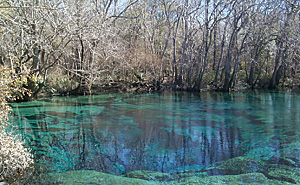
 The Floridan aquifer system is the most important freshwater resource in Florida and is also the source of several hundred freshwater springs. Cypress Spring in northwest Florida is a pristine example of these unique natural features. (Photo credit: Kevin Defosset of the Northwest Florida Water Management District, 2003.) |
Implications and use of aquifer vulnerability models are widespread and include development of wastewater guidelines, spring protection mapping, establishment of best management practices, and design of nitrate loading models.
Local agencies have extensively applied the results of local scale analyses. For example, the Marion County aquifer vulnerability model is used to prioritize watershed management projects in sensitive areas.
The Leon County aquifer vulnerability model is used to augment extension of sanitary sewer service and to protect Wakulla Spring, located south of the county.
The Alachua County model was adapted into an aquifer-protection zone map complete with other natural features like springshed areas and sinking streams.
Source: ArcNews, ESRI
More Information
For more information about FAVA and related projects and to access project data, visit www.dep.state.fl.us/geology/programs/hydrogeology/fava.htm or contact Alex Wood, president of Advanced GeoSpatial Inc. (tel.: 480-699-7800, e-mail: awood@adgeo.net); Dr. Jonathan Arthur, Florida Department of Environmental Protection (tel.: 850-488-9380, e-mail: jonathan.arthur@dep.state.fl.us); or Dr. Gary Raines of the United States Geological Survey (retired) (tel.: 775-323-4074, e-mail: garyraines@earthlink.net).
